Data, Distance, and the Making of Forest Carbon
Perry Maddox
by
Through the past decade, the monetization and trading of carbon emissions has been proposed as one pathway to address global climate change. To facilitate such trading, new strands of knowledge production are taking shape that seek to quantify and predict the absorption of atmospheric carbon dioxide, i.e. carbon sequestration, by forests. Their methodologies range from satellite monitoring of large-scale changes in land cover to the development of new field techniques for quantifying forest carbon stocks in situ. These new valuations and methods also mark a shift in international environmental policy. An emphasis on biodiversity, prevalent in the 1990s and early 2000s, is now accompanied, if not replaced, by a revaluation of forests less in terms of the number of species they contain than in terms of the amount of carbon they sequester. One effect of such recasting is that research and policymaking have expanded their focus from areas considered to be hotspots of biodiversity to include secondary forests and weedy landscapes of regrowth, such as the areas of rural Panama where I carry out my research.
Thus, the new processes of data collection and surveillance used to represent forested landscapes for climate policymaking have become salient for my work. In this essay, I consider new processes of collaboration emerging with these changes. I draw out a tension between perspectives from the air and from the ground to consider how a claim to data is conditioned by uneven power relations, even as would-be collaborators, such as forest scientists, Indigenous research technicians, and bureaucrats may seek to work against the hierarchies in which they are embedded. To make this argument, I build on insights generated in a Sawyer Seminar, which brought together anthropologists and forest scientists working at the conjunctures of forest science and climate politics (Mateo Vega et al. 2022).
Panama is considered one of the only carbon-negative countries in the world, meaning that its forests are calculated to absorb enough carbon in a given year to more-than-offset the emissions of the country’s entire economy. Its status as such is consistently mobilized by its representatives in international environmental fora, to position the nation as innocent, vulnerable, and a worthy recipient of both investment in mitigation and aid for adaptation. It is also home to the regional offices of the UN Environment Programme (UNEP) and the UN Development Programme (UNDP). Through this confluence of factors, it has become a laboratory for building the knowledge infrastructure to support carbon trading initiatives such as REDD+ (Reducing Emissions from Deforestation and Forest Degradation). Key elements of this infrastructure include systems for surveilling forest cover and monitoring atmospheric gas exchange; techniques for quantifying forest carbon; and baseline measurements against which to build scenarios for calibrating potential payments for ecosystem services.
The processes for building this infrastructure show how data itself can be generative of new social relations, particularly between metropolitan forest scientists and rural Indigenous and campesino peoples. While these engagements may be undertaken as good-faith efforts to avoid replicating colonial structures, they unfold in a social terrain saturated with uneven power relations. Processes of constituting data as such may therefore reinscribe hierarchies of knowledge, particularly if the terms of commensurability for what counts as data, how it fits into existing projects of knowledge production, are set in advance by governments, researchers, and funding institutions prior to any engagement with communities inhabiting the sites of research. Tracing between the perspectives of the air and the ground with an ethnographic sensitivity to knowledge production as a process, situated and contingent, helps to elaborate concretely how these relations take shape. These two perspectives are not inherently in opposition; richly productive research exists which integrates them, for instance by linking ecophysiological plant measurements with satellite data (Eamus et al. 2016), or by drawing upon satellite data as a form of evidence to document environmental violence (Weizman 2017). However, in the situation outlined below, the absence of this work of connection helps illustrate how power works through data.
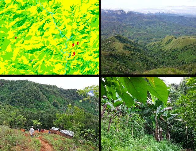
Four views of a single place. Upper left: SNBMN land cover map, here showing primarily 3 “types”: secondary forest; shrubs and bushes; pasture. Upper right: the same valley seen from a mountaintop, showing a mosaic of forest, natural savannah, swidden fields, and fallow regrowth. Lower left: view from a footpath, showing a house in front of a slope of fallow regrowth blending into forest. Lower right: a garden at the edge of the forest. Beyond the trellises of beans interplanted with bananas in the foreground, the forest behind is also planted with peach palm, cacao, and an edible understory palm. Upper left: Image by MiAmbiente 2015. All others: Perry Maddox.
However, while these knowledge practices may not require stepping foot into the forest, they do not go unnoticed from the ground. Javier Mateo Vega describes how a series of overflights for a lidar study of standing carbon stocks were themselves the impetus for Indigenous authorities in eastern Panama to become engaged in processes of knowledge production oriented towards forest carbon. These aerial surveys gave no consideration to prior consultation with the communities beneath, let alone to free, prior, and informed consent. In Mateo Vega’s (2022) words, the repeated overflights that the study entailed “generated a level of discomfort” in Indigenous communities living under the airplane’s path. Authorities of these communities approached biologists from a Canadian university who had been working in the area for decades, eventually forming a partnership with several institutions to develop new field research methods, train their own field technicians, and carry out a ground-based survey of standing forest carbon throughout their lands (Vergara Asenjo et al. 2017). In so doing, these authorities recognized the uneven power relations within which they were operating. Rather than seeking to integrate a different system of knowledge into existing scientific practice, they were developing the capacity to directly address authorities from the Panamanian government in their own technical language, while questioning the legitimacy of data produced through new forms of aerial surveillance.
At stake in this situation, then, was less a tension between different forms of knowledge than between perspectives of ground versus air. Indigenous authorities in this case were not contesting science as such, in the name of epistemological alterity. Rather, they were concerned more precisely with which scientific methods and technologies would enable what they considered an adequate understanding of their forests. Thus, they engaged in crafting their own scientific methods, in dialogue with outside researchers, to assert that data from the ground also mattered, that these forests were not transparently knowable from a distance. This move responds to the mutual embeddedness of knowledge and power not by contesting different “analytics of existence” deemed fundamentally incommensurable, but rather, by contesting from what position it is possible to know a landscape (cf. Povinelli 2021). A claim to data, here, is bound up in a claim to “carbon sovereignty”—language which both state and Indigenous actors employ with very different meanings. Rather than seeking to translate between incommensurable ways of knowing, Indigenous political authorities and forest scientists maneuver across epistemic difference in a way that was guided by their awareness of the power differentials shaping both what counts as data, and what political work a claim to data can do.
Other ways of knowing this landscape—intimate emplaced knowledges of more-than-human histories, for instance—could not simply be incorporated as data into another knowledge project with fundamentally different ends, such as “forest carbon” or “climate solutions” (Holmes 2010). Taking these knowledges seriously in a conversation about climate change would instead entail a much broader reworking of the questions asked, the ends imagined, and the terrain of power relations within which such a conversation may take place.
References
Eamus, Derek, Alfredo Huete, and Qiang Yu. 2016. Vegetation Dynamics: A Synthesis of Plant Ecophysiology, Remote Sensing and Modelling. Cambridge: Cambridge University Press.
Holmes, Tabitha R. 2010. “The Hierarchy of Epistemological Beliefs: All Ways of Knowing Are Not Created Equal.” In Studies in Meaning 4: Constructivist Perspectives on Theory, Practice, and Social Justice, edited by Jonathan D. Raskins, Sara K. Bridges, and Robert A. Neimeyer. New York: Pace University Press.
Mateo Vega, Javier, Elsa Ordway, Sarah E. Vaughn, and Julie Velásquez Runk. “Forest Life, Scientific Practice, Climate Politics.” 2022. Presented at the Sawyer Seminar on Precision and Uncertainty in a World of Data, March 11. https://worldsofdata.wordpress.com/2022/01/20/11-march-2022-forest-life-scientific-practice-climate-politics/.
McKittrick, Katherine. 2006. Demonic Grounds: Black Women and the Cartographies of Struggle. Minneapolis: University of Minnesota Press.
MiAmbiente Panama. 2015. Forest Cover and Land Use Map 2012 (Feature Layer). 1:50.000. STRI GIS Portal. https://arcg.is/14DHmv0
Povinelli, Elizabeth. 2021. Between Gaia and Ground: Four Axioms of Existence and the Ancestral Catastrophe of Late Liberalism. Durham: Duke University Press.
“SNMBM – Sistema Nacional de Monitoreo de Bosques de Panamá Multipropósito.” 2018. Panamá: MiAmbiente; UNDP; Forest Carbon Partnership Facility.
Vergara Asenjo, Gerardo, Javier Mateo Vega, Alexis Alvarado, and Catherine Potvin. 2017. “A Participatory Approach to Elucidate the Consequences of Land Invasions on REDD+ Initiatives: A Case Study with Indigenous Communities in Panama.” Edited by Rainer Bussmann. PLOS ONE 12(12): e0189463.
Weizman, Eyal. 2017. Forensic Architecture: Violence at the Threshold of Detectability. New York: Zone Books.
Perry Maddox is a PhD candidate in anthropology at Johns Hopkins University. His research moves between the UN climate change process and rural Indigenous and campesino communities in Panama to examine the formation of new policies and practices of knowledge production related to forests and land use. Specifically, the project traces how people from these communities, who have reclaimed and reforested lands previously devastated by large-scale cattle ranching, seek to position their experiences of re-habitation as useful knowledge for shaping climate policy, while drawing attention to the significance of ongoing labor in making livable landscapes. Perry’s research has been supported by the Wenner-Gren Foundation as well as programs internal to Hopkins.
Cite As: Maddox, Perry. 2023. “Data, Distance, and the Making of Forest Carbon ” In “data/Big Data in the field” edited by Naveeda Khan, American Ethnologist website, December 22 2023, [https://americanethnologist.org/data-big-data-in-the-field/data-distance-and-the-making-of-forest-carbon/]